The NASA-ISRO Synthetic Aperture Radar (NISAR) satellite has successfully captured and transmitted its initial radar images of the Earth’s surface, representing a significant achievement in the historic U.S.-India space partnership. The images, gathered in late August, provide an early insight into the satellite’s robust Earth-monitoring capabilities, with full scientific operations set to commence in November 2025.
Launched in July by the Indian Space Research Organisation (ISRO), NISAR is the inaugural satellite mission equipped with both L-band and S-band synthetic aperture radars, allowing for unmatched accuracy in observing the Earth’s surface — encompassing everything from forests and agricultural lands to glaciers and seismic activity zones.
“These initial images are just a preview of the hard-hitting science that NISAR will produce,” said Nicky Fox, associate administrator for NASA’s Science Mission Directorate. “It’s the most advanced radar system NASA and ISRO have ever launched.”
Credit: NASA/JPL-Caltech
First Targets: Maine and North Dakota
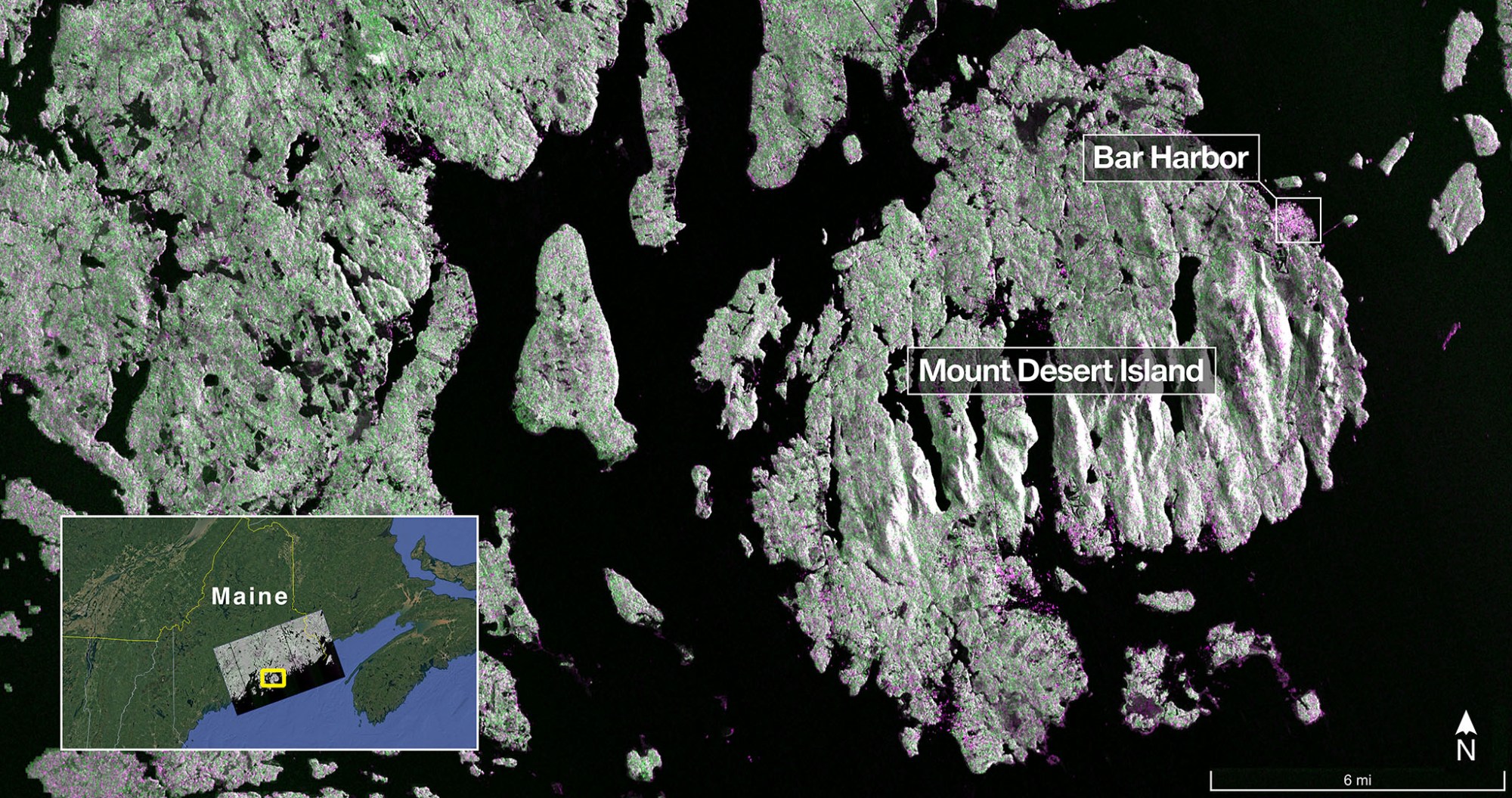
NISAR’s first image, captured on August 21, features Mount Desert Island along the coast of Maine. This striking radar image displays green regions as forests, while magenta indicates bare land or structures — prominently showcasing the town of Bar Harbor. The radar’s impressive resolution, down to 15 feet (5 meters), also makes visible the narrow waterways that cut through the island and the small surrounding islets.
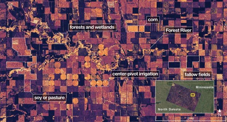
Just two days later, on August 23, the satellite obtained a composite radar image of northeastern North Dakota, covering Grand Forks and Walsh counties. This image highlights a varied landscape: light-hued wetlands and forests line the Forest River, while circular crop patterns and rectangular fields indicate active corn and soybean agriculture. The radar is capable of differentiating between fallow fields and those currently being farmed.
In contrast to optical satellites that depend on sunlight and clear skies, NISAR’s radar system operates continuously, regardless of the weather conditions. The satellite is equipped with an L-band radar, created by NASA’s Jet Propulsion Laboratory (JPL), which utilizes 10-inch (25 cm) wavelength signals capable of penetrating forest canopies, assessing soil moisture, and identifying minute surface movements — essential for investigating earthquakes, volcanic activity, and landslides.
On the other hand, ISRO’s S-band radar enhances sensitivity to small-scale features such as grasslands and specific crops, which improves the monitoring of agricultural ecosystems and their resilience to climate change.
Credit: NASA/JPL-Caltech
“The successful capture of these first images is a powerful reminder of what two nations can accomplish together,” said Amit Kshatriya, NASA Associate Administrator. “This data will help us understand Earth today and explore other worlds tomorrow.”
A Satellite Built for Global Impact
NISAR will scan the entire land and ice-covered surface of the planet every 12 days, using a 39-foot-wide (12-meter) antenna reflector — the largest NASA has ever sent into space. The spacecraft is currently orbiting Earth at an altitude of 464 miles (747 km).
When it reaches full operation, the satellite will provide critical insights for:
- Disaster response: Monitoring ground movement before and after earthquakes or floods
- Agriculture: Tracking crop health and irrigation patterns
- Climate science: Mapping glacier movement, sea level rise, and carbon-rich ecosystems
- Infrastructure monitoring: Detecting land subsidence that can threaten buildings and roads
A Symbol of U.S.-India Space Partnership
NISAR marks a new milestone in the expanding collaboration between NASA and ISRO. ISRO supplied the launch vehicle and the spacecraft bus, while NASA delivered essential radar systems, data management tools, and communication equipment. The satellite was launched from the Satish Dhawan Space Centre in India and is currently managed through ISRO’s Telemetry, Tracking, and Command Network.
“NISAR is not just a scientific triumph — it’s a diplomatic one,” said Sean Duffy, acting NASA Administrator. “This collaboration underlines our shared commitment to pushing the boundaries of space science for the benefit of all humanity.”


