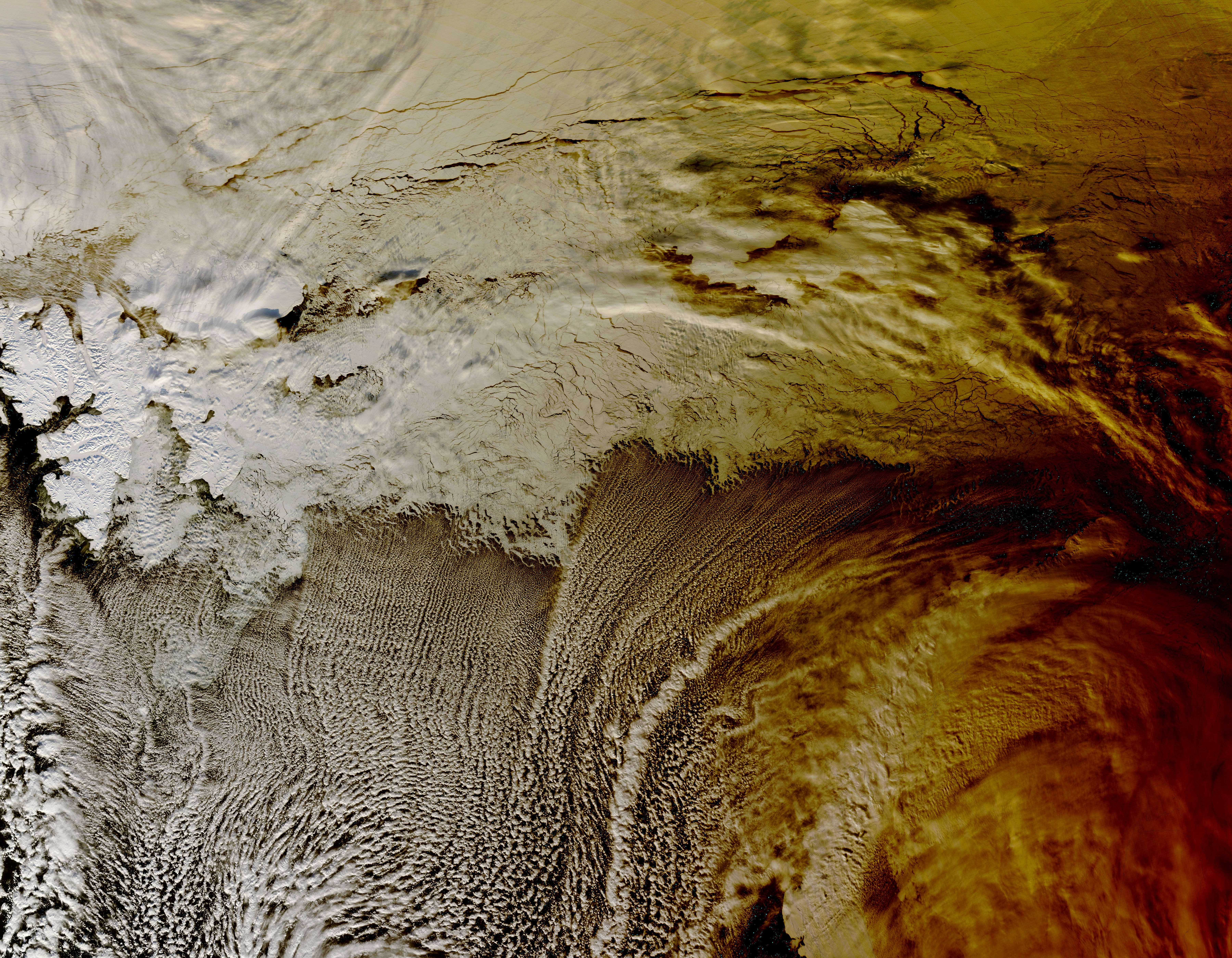

NASA’s Terra Satellite Sees the Shadow of the 2015 Eclipse On the morning of March 20, 2015, a total solar eclipse graced parts of Europe, while a partial eclipse was visible in northern Africa and northern Asia. At 10:45 UTC (6:45 a.m. EDT) on that day, NASA’s Terra satellite flew over the Arctic Ocean, capturing the shadow of the eclipse as it drifted across the clouds in that region.
Launched on December 18, 1999, Terra is about the size of a small school bus and is equipped with five advanced instruments that provide simultaneous measurements of the Earth’s systems. These instruments include:

- The Advanced Spaceborne Thermal Emission and Reflection Radiometer (ASTER) captures high-resolution images of the Earth, with pixel sizes ranging from 15 to 90 square meters, across 14 distinct wavelengths of the electromagnetic spectrum, from visible light to thermal infrared. Researchers utilize ASTER data to generate comprehensive maps that detail land surface temperature, emissivity, reflectance, and elevation. Unlike its counterparts, ASTER does not continuously gather data; instead, it averages about 8 minutes of data per orbit.

- The Clouds and Earth’s Radiant Energy System (CERES): Two identical CERES instruments are installed on the Terra satellite, tasked with measuring the Earth’s overall radiation budget and estimating cloud properties. This data is crucial for scientists to understand how clouds influence radiative fluxes from the Earth’s surface to the upper atmosphere. One of the CERES instruments functions in a cross-track scanning mode, while the other utilizes a biaxial scanning mode. The cross-track mode effectively continues the legacy of the Earth Radiation Budget Experiment (ERBE) and the Tropical Rainfall Measuring Mission (TRMM), whereas the biaxial mode offers new angular flux data, enhancing the precision of angular models that help determine the Earth’s radiation balance.

- Multi-angle Imaging Spectroradiometer (MISR): Many satellite instruments primarily focus on observing directly downward or towards the planet’s edges. To gain a comprehensive understanding of Earth’s climate and its potential changes, it’s essential to measure how sunlight is scattered in various directions under natural conditions. The Multi-angle Imaging SpectroRadiometer (MISR) is an innovative instrument created to meet this requirement, capturing images of the Earth from nine distinct angles. One camera looks straight down, while the others capture views at angles of 26.1°, 45.6°, 60.0°, and 70.5° both forward and backward. As it traverses the sky, MISR takes images of each area of the Earth’s surface using all nine cameras across four wavelengths: blue, green, red, and near-infrared.

- Measurements of Pollution in the Troposphere (MOPITT): The Measurement of Pollution in the Troposphere (MOPITT) is a sophisticated instrument aimed at deepening our understanding of the lower atmosphere and its interactions with both land and ocean ecosystems. This tool specifically investigates the distribution, movement, sources, and sinks of carbon monoxide within the troposphere. Carbon monoxide, released from industrial activities, vehicles, and wildfires, disrupts the atmosphere’s natural processes for eliminating harmful pollutants. MOPITT stands out as one of the pioneering satellite sensors employing gas correlation spectroscopy. It captures emitted and reflected light from the Earth across three distinct spectral bands. As this light travels into the sensor, it navigates through two separate paths that contain carbon monoxide. The varying energy absorption along these paths results in slight differences in the signals, which correspond to the presence of these gases in the atmosphere.

- The Moderate Resolution Imaging Spectroradiometer (MODIS)-With its expansive 2,330-km-wide viewing area, MODIS captures images of every location on Earth every 1-2 days across 36 distinct spectral bands. This capability allows MODIS to monitor a broader range of the planet’s essential indicators than any other sensor on Terra. For example, it tracks the percentage of the Earth’s surface covered by clouds nearly every day. This extensive coverage, combined with data from MISR and CERES, enables scientists to assess the effects of clouds and aerosols on the Earth’s energy balance. Beyond just tracking cloud cover frequency and distribution, MODIS also analyzes cloud properties, including the size and distribution of droplets in both liquid and ice clouds.
On November 28, 2024, one of Terra’s power-transmitting shunt units experienced a failure. A response team assessed the satellite’s condition and considered the potential consequences and options. As a precaution, they placed ASTER into Safe Mode, which means that data collection from ASTER has temporarily halted, while all other instruments continue to operate normally.


